I was there today. We happened to notice the smoke over Kilauea while driving to Hilo, then checked out USGS cams, and immediately drove there and spent the next 7 hours getting mesmerized.

As my first eruption encounter, I didn’t expect to experience several things like the heat even from a long distance, enough to keep me warm in my shorts at 60F, and the loud rumble, like a giant waterfall. The flow of lava was way faster than I expected too, almost like oil.

Mind blown.

Hawaii volcanism is what geologists seem to call "nice and friendly" - low viscosity lava, not prone to explosive eruptions (unlike the stratovolcanoes of the Andes or the Pacific rim in general) - this is because it's caused by hotspot volcanism in Hawaii.
It’s not nice and friendly because of the hotspot volcanism.

It’s because the hotspot has a chemical composition that is generally low in dissolved gasses and very liquid/flows well. (Lots of silicates I think?)

It tends to come out nicely and stay liquid as it leaves, so vents don’t plug up. Also, because of the relatively low dissolved gasses, pressure doesn’t spike as high when it’s flowing out of the chamber like many other magmas do, causing explosions.

Hawaii exists basically because it’s great for building up islands/mountains without blowing them up as part of the process.

Low viscosity is due to the LOW silica content. Tectonic setting is the primary factor determining the magma's final composition (basaltic) and therefore its physical properties (low silica, low viscosity). The gentle nature of Hawaiian volcanism is a direct result of its basaltic magma, which it has because the hotspot is located under thin, basaltic oceanic crust
I don't think hotspots can be said to have different composition. But if the hotspot is under a continent or an ocean plate makes a difference for the type of eruptions. Hawaii is in the middle of an ocean plate, no continental crust there. So we get a basaltic eruption (comparatively lower silica content, low viscosity lava).
Yellowstone is also caused by hotspot volcanism. The friendly eruption is a property of location, not hotspot origin.

Your initial post read the other way, which the parent post is addressing.

  • mdani
  • ·
  • 5 hours ago
  • ·
  • [ - ]
Same here. I'd add that viewing the lava fountain at night was a mesmerizing experience. You get to see the full extent of red, glowing lava lake and the fountain. There were thousands of people and yet they appeared so small in front of the volcano. We did experience some ash and Pele's hair on the way to the park, near the black sand beach. I do recommend carrying a torch though at night, since it is pitch black at night. The lava illuminated the park with the red glow, but there were some parts where you do need a torch esp. if you park far away and walk.
> viewing the lava fountain at night was a mesmerizing experience

Is there anything comparable to the overview effect [1] that attends seeing a lava fountain in person?

[1] https://en.wikipedia.org/wiki/Overview_effect

I am severely tempted to hop on a flight to go and see it, but wondering if it's such a "once in a lifetime" thing to go see? That, and if it'll peter out by the time I get there, and $500+ to just fly on a whim and stay overnight.
I was at the Fagradalsfjall eruption at 2023. Had been to Iceland for two weeks w wife and daughter, and on the last day (since the signs were there) I decided to postpone travel home for two days (w + child wanted to go home). On my last day, the hike opened up and I went at approx 2100 hours to the volcano. That was an approx 10 km hike one way.

Amazing experience. A bunch of us were stupid as can be, but got as close as approx 50 m. Sounds really dangerous, but the sputter were not that violent yet, and the ground sloped away from us. Still, really stupidly dangerous (the sputter wall could've broken down, wind direction change, etc). But it didn't. Lots of moss fires, and walked into a small slope and immediately felt a sting in my nose and lungs from trapped gases so took that as a nope and went back.

Started walking back at 0130 something, boarded flight at 0600, fainted (I had done Mt Esja in the morning too). Sorry other passengers, it was inconsiderate of me and I was an asshole for that. But... that experience...!

  • mertd
  • ·
  • 4 hours ago
  • ·
  • [ - ]
I was reading about shield volcanoes and it sounds like the low viscosity lava is the defining feature. So the flow is par for the course.
Hawaiʻi Volcanoes National Park is absolutely stunning (and safe, away from the closed area). It's like being on a different planet. If you haven't been to the Big Island and the park, you should add it to your bucket list.
Decades ago, my wife and I visited the Big Island during a fairly sedate eruption. We drove down Chain of Craters Road, got to see a tiny lava flow (talking like a couple feet of glowing honey), but were wanting more. In the distance, we could see a huge steam column where a lava stream was reaching the sea. We asked one of the ever-attendant Park Rangers if we could walk over there. He said no.

But then he said - we close at 5pm, and there are no gates. OK, we can take a hint.

We drove to Hilo and bought cheap tennis and flashlights, then scurried back down Chain of Craters after 6. As the sky darkened, we walked towards the steam column. The rocks beneath our feet showed incandescent glows deep in the cracks, and we started to smell burned rubber from our cheap tennis. Eventually, we came to the lava outfall.

We watched nearly an hour as a river of molten rock cascaded into the ocean. We used our water bottles on our shoe soles, turning back when we ran dry.

I now understand that we were stupid - apparently the park loses a few tourists to shelf collapse each year - but we lived, and the memory is a treasure. Thank you, Mr. Ranger.

And yes, it's like being on a different planet - like being on our own, maybe 4 billion years ago.

  • ·
  • 15 hours ago
  • ·
  • [ - ]
  • 14
  • ·
  • 19 hours ago
  • ·
  • [ - ]
Not stupid. Just experiencing life and sometimes amazing experiences have a chance of danger. You get to choose what risk levels you are okay with. Props to that ranger who agreed with that belief.
Choosing your risk level and working within it isn't stupid. Not knowing the risk when it's easy to gather some more info and then acting in ignorance is, which is what GP was describing, and likely why they called their own actions stupid.
At that time, we had no kids & no pets, nobody directly dependent on us. That figured in our conversation on the drive to Hilo. Nowdays, we might come to a different conclusion, but I'm glad for the path we chose then.
  • serf
  • ·
  • 16 hours ago
  • ·
  • [ - ]
it's all whimsy and adventure -- but the reality is that you're not just risking your own lives but also the lives of potential rescuers.

just food for thought. I'm not about to say one should lead a safe and sterile life, but there is more to it than direct dependents.

Though rescuers did consciously choose that role and that they’d be saving ignorant people very often
  • Vinnl
  • ·
  • 3 hours ago
  • ·
  • [ - ]
I wonder if, if you'd talk to a rescuer, they'd agree...
Doesn’t mean you need to add more opportunities for people to get hurt or killed when you know better.
Rescuers choose their jobs too.
doctors choose their jobs too and they generally encourage people to stay out of the ER
That's completely irrelevant. Rescuers can encourage people to be safe, that's expected. they chose that job , despite it's dangers, because they care about those people being safe.

They know the danger and chose the job. That's the relevant bit.

I think you missed their point - just because you choose a job doesn’t mean people shouldn’t try to avoid needing to be rescued in the first place
Especially since that path didn’t collapse ;)
> The rocks beneath our feet showed incandescent glows deep in the cracks, and we started to smell burned rubber from our cheap tennis.

When I was there, this happened in the area that the rangers guided us to. There was an active flow of pāhoehoe at the time, which we could get as close to as we wanted - the heat was a strong disincentive to doing anything dumb. We were warned at the start that shoes with rubber soles would be ruined, but that warning was too late for me and I had no alternative. It was certainly worth the price of a pair of sneakers though.

Haleakalā is like this as well. Don't just drive up the crater - hike through the thing. It's a ~12 mile hike. It's a remarkable experience because the landscape changes so frequently and dramatically from desert to tropical forest.

The only comp to this is like the transition in Max Max from the desert to the oasis.

Tourists that drive to the crater, take pictures, and drive down have no idea what they're missing.

Highly recommend camping in the crater on a clear night around new moon. Some of the best stars you'll see. Seeing the sun rise in the crater gap (where you can sometimes see the big island) is stunning.

Park in the lower lot, hitchhike to the top (or get someone else to drive you), and then you can hike back up to your car the next day on the switchbacks.

Do not attempt to hike up the sliding sands trail you took down, it's *very rough*.

  • ·
  • 14 hours ago
  • ·
  • [ - ]
> Tourists that drive to the crater, take pictures, and drive down have no idea what they're missing.

And for some reason blather on and on loudly up there when the most mind blowing sunsets are happening. Can we not be silent for 15 minutes and look at the universe doing it's thing?

Sadly there was an ongoing eruption when me and my SO visited the Big Island, so the entire park was closed. Was a bit bummed out, on the other hand people lost their homes so keeping it in perspective.

That said, I second visiting the Big Island and visit various sites. Driving less than an hour and going from barren volcanic landscapes to lush rainforests was something else, and watching the sunset from Mauna Kea was magical. And lots of great beaches, and most that weren't next to a resort had very few people.

While the island is big relative to the other Hawaiian islands, its small enough that you can drive around it in a day.

I'd recommend staying on the Kona side, which is the dry and somewhat barren side. The Hilo side has rainforests for a reason.

What struck me about the big island is that it has 8 of the 13 climate zones, and you can go around the perimeter of the island in about 5 hours.

I loved going up Mauna Kea visitor center and stargazing. At ~11,000 feet, it's one of the best places in the world for naked eye stargazing. You're literally above the clouds, the island has strict rules about exterior lights at night to minimize light pollution, and you're above the thickest air. I wasn't expecting to see the Milky Way so easily.

https://en.wikipedia.org/wiki/Milky_Way#/media/File:Milky_Wa...

The Big Island has good B&B's in many parts of the island so I recommend staying in multiple places, to see the local sights without a long drive afterwards.
A university professor here visits many areas. He complained by far the most of the dust in the air that stuck around for quite a while there.
Definitely a place to visit if you can. I traveled there in 1983 just as it was starting to erupt and visited a lot of places that are now under lava rock! In a later visit we were walking out to see one of the "peep holes" where you can see the lava down below and the rocks started getting slippery, except they weren't slippery it was our shoe soles melting, oops.
As postal mentioned below, Haleakalā is fantastic for that.

Also, I recently visited Mt. Aso in southern Kyushu of Japan and it really felt like I was on Mars.

Went there a little over a year ago. The steam vents were active, but no eruptions. The exhibits are wonderful and the birdsong in the evening is amazing.
birdsong? are you talking about coqui frogs?
There are a half dozen or so different species of birds in the lava tube jungle areas. If you ever get a chance to go there just after dusk, you will be amazed. (Yes, the frogs make noises too.)
How would you compare it to Iceland regarding volcanoes and all? Thats what we Europeans have in our backyard and its a properly stunning and otherwordly experience.
I had a look at the crater using Google maps. Does this user contributed photo look AI to anyone? Or at least 'shopped. https://maps.app.goo.gl/or6gj5XnTCTwv4Ys7
  • nsoqm
  • ·
  • 11 hours ago
  • ·
  • [ - ]
You just have to look at the picture of the person who uploaded it: https://lh3.googleusercontent.com/a-/ALV-UjW5veVXQHmH8s4Db3W...
  • mertd
  • ·
  • 4 hours ago
  • ·
  • [ - ]
What's the play here? Afaik there are no monetary perks to being a top maps contributor.
Perhaps they're seeding the account with "harmless" contributions before using it to make fraudulent business reviews etc.
That photo is pretty clearly fake.

* The steam from lava should be arising from where the lava hits the lava, boiling it--there's not going to be any steam from the interior of a lava tube, because all of the water will have boiled out long ago.

* It looks like somebody dumped a photo of a black rock field on top of a different image. There's a sploch of a normal tan-sand beach at the base of part of this cliffs; in recent lava activity, the lava will extend fully into the ocean and collapse. Given that the edge of the lava is a) pretty towering and yet b) some distance from the sea.

* The lava activity in the extreme foreground is pretty sketchy. It's not entirely implausible to have lava flowing into a pit like that in some fashion, but there's also no clear source from the lava, and real Hawaiian lava flows tend to look somewhat different than that.

* Lava flows downhill from a rift zone. Where's the rift zone here? It's basically a wall of black rock. Photogammetry is not my strong suit, but the presumably dried lava is towering above the treetops in the distance, and yet there's no clear sense of where the lava is flowing from.

* In the background, you see something more akin to a stratovolcano (actually, might well be an eroded granite dike or some other weird formation like that as opposed to a volcano in the first place). Hawaiian volcanoes are shield volcanoes, they don't look like that. Also, Kilauea and Mauna Loa are too active to really have the deeply-eroded look like that. You have to go to Kohala on the Big Island to get that kind of look.

* Kilauea is nowhere near the ocean. (Also, shield volcano, you can't see the top from the base.)

* There's another island clearly visible in the background. None of the Hawaiian islands are close enough to each other to generally be visible from one another! And certainly not from any view of Kilauea, which is the last volcano in the chain that's above sea level. (Loihi still has another 3,000 feet to go before it pokes above the surface.)

Not saying this isn't fake, but erupting lava produces plenty of volatiles, including steam. These gases coming out of solution is what drives it to the surface.
I agree that image is as fake as can be. I reported it. Nitpick though:

> None of the Hawaiian islands are close enough to each other to generally be visible from one another!

Of the Hawaiian islands usually identified as "major", Molokai, Lanai, and Kaho‘olawe are all visible from Maui, and vice versa.

Many people would probably limit the list of major islands to four. Interestingly there doesn't seem to be any official term for that grouping, other than perhaps the "main islands".

You can actually sometimes see the big Island from the Haleakala summit!
There's a lot of really spammy data on Google maps that should be pretty easy for them to detect too. Go look at some remote locations and you'll find lots of images that advertise businesses, products and all sorts. Wondering if they're using it for image hosting.
Nothing looks right. The waterfall of lava to the caldera. How do you get magma ring above a non erupting caldera? It's 100% fake.
  • ·
  • 17 hours ago
  • ·
  • [ - ]
That user has submitted 58,000 photos. It's AI. Everyone should be reporting the photo and the account.
  • ·
  • 6 hours ago
  • ·
  • [ - ]
It’s not real, lava has not flowed into the ocean for many years.
This screams AI, 100%
Are these giant buildings over there? Would be easy to check their existence (though the photo could be real but the lava is not)
That arcing of the lava really is something to behold. The pressures to push molten rock like that are impressive.
It's just the weight of literally everything on the planet pushing down, as well as miles of rock :)
Indirectly. The actual spike of pressure that ejects the magma comes from the gasses dissolved therein. When the magma moves up, the pressure drops and the gasses become oversaturated and thus prone to violent release.
“just” is doing a lot of heavy lifting there ;)
Literally! :-)
Indeed. I just wish we could get a better sense of the scale, which is always hard in nature shots devoid of trees or human structures. A productive use of AI would be to place some houses and automobiles in the video for scale.
icy what you did there
Looks like the camera and stream are still active...

https://m.youtube.com/watch?v=BqmpkUdMtyA

They have three cameras, well, had three. The south rim camera (v3) was overrun by the eruption at about 0957 local time, you can rewind the stream and watch its final moments.
Starting at 9:46 is when it goes from wow to WOW. The last 2 minutes in particular are incredible, including the bizarre artifacts in the last 15 seconds before the stream dies.
It's wild to see this footage safely behind a monitor. Kind of macabre to ponder but I wonder if the victims of Pompeii had a similar experience. The last we see is a hailstorm of ash and molten lava raining down then signal lost.
there is a poignant set of images taken by a photographer Robert Landsburg who chose to post himself too close to the blow up of the top of Mount Saint Helens in 1980.

the last picture from his salvaged camera is similar to what we see for this topic: https://allthatsinteresting.com/wordpress/wp-content/uploads... his camera was found under this body, with speculation that he was protecting it, which doesn't seem unlikely, but it also would not be surprising for him not to have had that presence of mind, things were happening very quickly.

https://allthatsinteresting.com/robert-landsburg

From that article:

After taking his final photograph, Landsburg removed the roll of film from his camera and placed it in a canister. He buried the camera and the film canister deep in his backpack. Then, he placed the backpack on the seat next to him and covered it with his body.

It was more than just jumping on top of his camera. Sounds like there’s some confidence about his intention.

  • toss1
  • ·
  • 19 hours ago
  • ·
  • [ - ]
iirc, Pompeii was a pyroclastic flow [0], a fast-moving current of hot gas and volcanic matter with speeds between 100-700 km/hr and temperatures up to 1000°C. So, probably something like that, but a lot bigger, faster, and arriving faster from further away.

I was surprised how long the camera lasted getting buried. It'd be a not good end.

[0] https://en.wikipedia.org/wiki/Pyroclastic_flow

Just to add, there are two main categories of volcanism, shield volcanoes (hot spots, mid ocean ridges) and stratovolcanoes (continental and subduction zone volcanoes). Hawaii is the first kind ("tourist friendly"), Vesuvius at Pompeii is the latter kind (not friendly). The main difference is the silica content, the stratovolcano lava is sticky and viscous; it gets stuck and things get explosive and nasty.

We have a lot of stratovolcanoes around the pacific rim so it's eruptions like those that we should compare with Pompeii, and not really Hawaii.

The two categories also produce, in general, different kinds of rock.

https://youtu.be/T02pJdKARLo

Here is a pyroclastic flow from two weeks ago. In the first minute you can watch it boil a rainforest to tree trunks. That is an insane amount of heat to do that, green stuff is full of water and doesnt like to burn.

i just posted a sister comment to yours about the Mt St Helens explosion, with a picture from 1980, and then i noticed that they are calling (it's a non technical article) what rained down in the photograph onto the camera and photographer "pyroclastic flow" and it looks very similar to what happened here.
  • db48x
  • ·
  • 12 hours ago
  • ·
  • [ - ]
This is not a pyroclastic flow and doesn’t look even remotely similar. The problem is that you’re comparing a very close up image of some lava falling on a camera to videos taken from tens of miles away from Mt St Helens. The scale and nature of the event are completely different.

Weirdly if you are going to be hit by a pyroclastic flow then it won’t be moving across your field of view at all. It’ll just be getting bigger and angrier–looking for the minute or two that you have left in your life.

https://youtu.be/T02pJdKARLo?si

This is what a pyroclastic flow looks like.

Yeah, they likely saw it racing down the mountain and then met their doom fairly immediately.
Kilauea is more or less constantly erupting. This is the 38th eruptive episode since in the past year: https://www.usgs.gov/volcanoes/kilauea/science/eruption-info... (note that the 38th episode started a few hours ago as of this message). Although this is still considered "one" eruption by USGS.
Although it will stop erupting any time I get on a plane headed there. Same for Iceland.
Probably this amazing capture is worth more than a hundred times the price of the camera, yet the geek in me feels really sad when perfectly functional hardware gets destroyed :)
Definitely don't think about how much "nice" equipment is bought, used once or twice and then sits in a cupboard forever until disposed of in a skip when someone dies or a company goes under and the building is cleared.

My last place had a whole box full of FPGA dev boards that I would have killed to play with as an undergrad.

The real pities are in machining where what looks like a junk heap to the family may actually be a priceless trove of rare tools and irreplaceable machine parts. Not to mention lovingly-made tools and jigs. A physical cousin to unpublished software sitting on a thrown-away hard drive.

Think of it like a delicious meal or a grenade. You pay for it to be consumed once, then it's gone.
When I walked across the crater as a kid, I remember there was an inner crater that I was told had filled up with lava back in the 80s and then drained down leaving a deep well. Does someone have a map of the historical eruption locations within the main summit crater?
USGS has a page on the history of Kilauea here: https://www.usgs.gov/volcanoes/kilauea/science/geology-and-h..., which also has some links on some of the eruptions in recorded history.

Probably the closest thing to what you're looking for is here: https://www.usgs.gov/media/images/kilauea-caldera-simplified..., which lists the age of the most recent lave flows as of 2008 (when Halema'uma'u started filling up again). The 2018 eruption caused another caldera collapse within the crater, enlarging Halema'uma'u and creating a new mini-caldera that's labeled as the "down-dropped block" in subsequent maps, e.g. https://www.usgs.gov/maps/october-5-2021-kilauea-summit-erup... ... although, since then, Halema'uma'u has erupted enough lava to more or less fill the entire down-dropped block, see, e.g., the most recent map: https://www.usgs.gov/maps/november-25-2025-kilauea-summit-er...

  • 333c
  • ·
  • 15 hours ago
  • ·
  • [ - ]
The AI narration was off-putting, but the video footage was cool.
That is not AI. The same voice narrates at least two years ago. Just scroll down in the channel's video list.
The description of the video states it is in fact AI:

> A synthesized text-to-video voiceover was used in the narration for this story.

Where does it say that? I can’t see it in the video description.
The second line. The video description for me says the following:

"HAWAIʻI VOLCANOES NATIONAL PARK - An incredible sight at the summit of Kilauea volcano on Saturday morning, as Episode 38 erupted enormous lava fountains across the caldera, destroying one of the webcams that was live streaming the event.

All images and video are courtesy the U.S. Geological Survey. A synthesized text-to-video voiceover was used in the narration for this story."

Well it would've been better if they kept the video on the actual camera that ate it instead of switching back and forth constantly. It's not Liam Neeson climbing a fence, guys.
This was incredible to watch, and I have to chuckle at this title. It's obvious why the webcam matters, with people round the world watching, but the destruction of a webcam is such a tiny thing in comparison to the eruption itself it's strangely funny.
Would be nice to have a mobile phone live streaming webcam viewer that vibrates when the webcam is destroyed!
Here’s a video I took of an eruption in June: https://youtu.be/BGOSSNy1hN0?si=MIFkW7MkRDxJ5tUr
More detailed coverage from Geology Professor Shawn Willsey [1]. He’s a good channel to follow if you’re even slightly interested in geology…

[1] https://youtu.be/oc2Pr3YiRO0?si=UJInJ_wLzitdKec8

The Big Island of Hawaii and the national park there is an amazing place. One of the only places where you can (relatively) safely visit a highly active volcano.
Worth watching: Into the Inferno, a film by Werner Herzog in which he depicts the relationship between active volcanoes and the humans who live in their shadows.
The final moments of the webcam were even better than I had hoped.
That thing took a licking and kept on ticking.
The two events in the title sound so uneven
Pretty cool - that looks like two or three eruption holes.

Now someone timejump to krakatau, year 1883 ...

If we're lucky, we (humanity) get to experience another supervolcano eruption sometime in the future, and then we'll finally get some good content out of it.
Personally I’m looking forward to a nearby supernova or giant meteor impact!
How about waiting for a Geomagnetic reversal? They happen on average every .45M years, the last one .78M years ago, big chance one happing anytime now :-)

https://en.wikipedia.org/wiki/Geomagnetic_reversal

I'd love to learn more about the specific failure mode towards the end. As the eruption debris approach the camera, we see glowing rock up close. The camera then flashes purple for some reason, goes black, then returns to streaming for a few more seconds, recording a vague orange glow. After that, it's gone for good.
A little bit of educated guessing on my part:

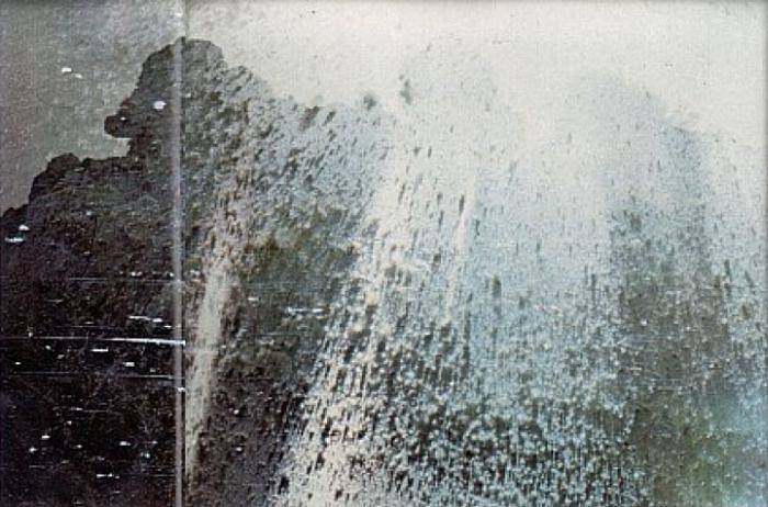
The purple frames have a bunch of gradients to white, which looks a lot like what happens when the infrared filter on most color cameras is removed and a bunch of IR light is shone into then. For some reason the green cells are less sensitive to IR, which results in a purple-ish hue. So in this case, perhaps the lava striking the camera melted through the lens holder and shifted the IR filter out of place, or is just able to shine intense IR light into the gap between the filter and the sensor.

In those same frames, the dark areas with noisy borders are I believe an artifact of the CMOS sensor digitization process when cells get strongly overwhelmed. I've seen the same patterns on cameras where an extremely intense light (e.g. a laser pointer) is shone into them. It's like the cells get so overwhelmed they roll around back to zero.

The amorphous shapes at the very end are clearly from the lens being totally detached / moved out of position, allowing defocused light to hit the sensor. I didn't spot any interesting sensor or encoder death frames before the video ends, so likely the lava severed the ethernet cable or destroyed the electronics at that point.

Just a planet popping a zit.
The threat level for airplanes is set to orange... for anyone dumb enough to fly over an erupting volcano. The orange flying from the ground would be all the motivation I need to stay clear of it.

It was an awesome video, though.

I dunno... Different times, different risk tolerance.

Back in 1980, my dad was sitting at his desk in Bellevue one morning when news came in that Mt. St. Helens was erupting. Him and a pilot friend had the presence of mind to head straight to the local airport and rent a plane.

"Be careful not to head South. Mt. St. Helens is erupting, and you sure don't want to get close that by accident."

"Oh, yeah, sure. No way we'd do something like that."

He has this amazing framed aerial photo of the mountain with the ash plume rising. Evidently, the flight home was pure chaos, bobbing and weaving to avoid dozens of midair collisions since every other pilot in the Seattle area had had the same idea, but 45 minutes later.

An erupting volcano can spew ash over a large distance. When Eya.... that Icelandic volcano (that's hard to spell because I don't know Icelandic) erupted several years ago, the ash cloud traveled far enough to disrupt travel over most of Europe for a few days.
A favourite tidbit from that time: Icelandic post released stamps of that eruption and it was used for European postage (mail to Europe).

https://findyourstampsvalue.com/news/stamps-created-from-eyj...

(Stamp is marked "Bref til Evropu" - European postage)

Eyjafjallajökull
> The threat level for airplanes is set to orange... for anyone dumb enough to fly over an erupting volcano.

Even 180km away from the eruption, airplanes can be seriously damaged [1].

Jet engines really, really do not like to ingest anything else than air and, maybe, a tad bit of water.

https://en.wikipedia.org/wiki/British_Airways_Flight_009

Volcanic ash is particularly bad because it is so abrasive, having been freshly formed without any opportunity for erosion to smooth it down like regular dust.
That's not the only problem - volcanic ash also has a low enough melting point that it'll melt in the combustion chamber of a jet engine and leave glassy deposits on cooler components.
Prevailing winds are key. Reykjavíkings told me that during that big eruption many moons ago, all traffic to Europe was ended but traffic to North American continued merrily along.
>A synthesized text-to-video voiceover was used in the narration for this story.

I wasn't even realizing it without reading this in the description.

A new entei has been born?
Just FYI, but the voice for this channel is AI generated.
Synthetic text-to-speech and “Ai” generated are not the same thing. We’ve been doing TTS for 30 years now - get over it
The toughest thing to realize is that it is not obvious. Other posters here say it's a human, which was my assumption. But I wouldn't bet my savings either way anymore.